Thankfully, my home hasn't had any flooding problems at all. One of the main intersections about a mile away from my place was flooded last weekend when it was raining so hard for so long, but no flooding near my home. I don't live near the downtown area where the Mississippi River is supposed to crest on Wednesday, or the Wolf River.
If you'd like help to help flood victims in the Mid-South, please donate to the American Red Cross.
Here's how the flooding looked through my eyes today, May 8, 2011. Take a ride with me...
This is the corner of Union Ave and Front Street, on top of a hill. Once you are on the very top of the hill, a few farther feet from where this was taken, you can see the Mississippi River and Riverside Drive.
Those the trees in the distance are on Mud Island. Click on that link to see what it normally looks like on the Island. Just to the left of this picture are police on crowd control and big road block signs. The road is blocked because the River has flooded out part of Riverside Drive.
Driving on Interstate 40 west, towards Arkansas. All that water on the right is not supposed to be there.
The water rarely crosses over that tree line, either.
Yes, the river water is really that close to I-40. It's almost unfathomable.
This sign shows that we are 2 whole miles West of the Mississippi River and there is STILL River water.
These are barricades to help keep the water off the interstate.
This is farm land, now covered by the River. See the train tracks? The railroads aren't running right now because parts of the track are flooded. I saw it with my own eyes and it's still hard to wrap my head around!
No zooming in, this is really what it looked like out my passenger window on I 40 today.
Nearly 3 miles into Arkansas before it starts to look a little bit normal. My heart aches for these farmers...
We exited I-40 and got on I-55 North in West Memphis, AR. Even worse on that side...
Again, no zoom used here.
All the water you see here should NOT be there. It's amazing how w i d e the Mississippi River has spread!
The water is very close to the barricades!!
Water + power lines = disaster waiting to happen. Scary surreal stuff!
And then there's the sludge and stink of River water. When the River recedes, in about a week or so it's going to leave behind an enormous and stinky mess. Brings back bad memories of Hurricane Georges destroying all my stuff when I lived in the Lower Florida Keys in 1998.
This is just over a mile from where the Mississippi River usually starts.
Water, water everywhere!
This is the other end of Riverside Drive. You can see the River in the distance.
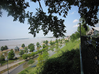
We stopped at park that runs along the top of a hill over Riverside Drive. The spot where all those trees are is usually where many Memphians watch the fireworks on the 4th of July.
This shows how high up we were from Riverside Drive. Also, shows that the River not only crossed the road but has flowed up the big hill onto the grass. In the far distance you can see the famous Memphis 'M' bridge.
I zoomed in here to get a better shot of the crazy high water line.
The downtown trolley is still running, though!
If you'd like to see more (and, yes, better) pictures of the Memphis flood, take a look at my personal favorite local station News Channel 3, WREG. Making history in Memphis, which made for a very memorable Mother's Day.


No comments:
Post a Comment